Johnsons Lake, Salisbury, Maryland
A continuing essay.... brought
to you by Grandfathers Clock
Grandfather's Clock
Top Page Profiles Credits
Johnson Lake Photos
Johnsons Lake is situated in Salisbury, Maryland at the head waters
of Wicomico River's "north prong" and reaches from the dam near Isabella
Street in Salisbury North to the Naylor Mill road area, where it changes
to streams with surprisingly deep channels. It runs under Naylor Mill road
and north to the next upstream resevoir at Leonards Mill Pond.
The name of the lake and the dam holding back its water has changed
multiple times over the past couple hundred years. Mills for sawing lumber,
grinding grain, carding wool and even an electric power plant have drawn
their power from the water of Johnsons Lake tumbling into the Wicomico
River. In the age of hydro-mechanical power these dams often were refered
to as mill dams.
The Wicomico River and Johnsons Lake divide Salisbury. A major east
/ west route, Isabella Street, crosses the site where the lakes dam originally
stood for many years. Traffic of all kinds, auto, horse and buggy and foot
traffic have traversed the river at this site for over 200 years. Legend
has it that area Indians also crossed at this spot on a walkway made from
"saplings punched into the river bottom and strung together with vines".
(1)
In 1758, a mill dam was built there by a man named Bailey and atlases
of the late 1800's show Isabella street crossing over the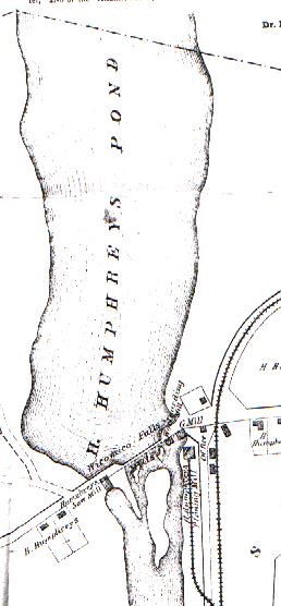 dam with mills adjacent. (2) Gray's New Map (1877) of
Salisbury depicts Johnsons Lake, then called H. Humprhrys Pond, pictured
at right (not to be confused with Thos. Humphrys Lake which fed the
other prong of the Wicomico River). This series of detailed maps consisted
of many areas showing roads, residences, land features as well as business
locations and references. While there can be some question to the accuracy
of scale or dimension to these old maps, it is an excellent snapshot of
the time.
dam with mills adjacent. (2) Gray's New Map (1877) of
Salisbury depicts Johnsons Lake, then called H. Humprhrys Pond, pictured
at right (not to be confused with Thos. Humphrys Lake which fed the
other prong of the Wicomico River). This series of detailed maps consisted
of many areas showing roads, residences, land features as well as business
locations and references. While there can be some question to the accuracy
of scale or dimension to these old maps, it is an excellent snapshot of
the time.
One hundred twenty years ago the dam was called Wicomico Falls and served
as the power source for several mills. This mill site, with power from
the falls along with railroad and sailing ship access, was a prime business
location. Humphreys Saw Mill was situated on the west side of the "Mill
Falls" and a wool carding mill, grist mill and H. Humphreys Planning Mill
were to the East along the railroad. An 1890 photograph depicts the "Isabella
Street Falls" with adjacent mill buildings.
The business reference on the old map describes Mr. H. Humphreys business
as:
"Manufacturer of and Wholesale and Retail Dealer in Dressed Flooring,
surfaced Boards, House-framing, Box-boards, Oak Lumber suitable for Vessel
Material, Gum, Walnut, Oak and Cherry Hubs, Balusters, Newel Posts, Fence
Picktes, Post Caps, Flowere Vases, Broom Handles, Spinning Wheels, Pumps.
Turning of all Kinds and Styles of Wood and Iron a Specialty. Wool carded
from July 1st to October 31st. Also Manufacturer of Flour, Meal and Feed
Stuff. Wicomico Falls Mills, No. 2 Mill Street, Salisbury, Md."
The mill dam at Isabella Street failed a number of times over the
past 100 years carrying a torrent of water and debris down the river each
time.
In 1926 a major Hurricane which caused massive dammage and death in
Florida pounded the East Coast with excessive rainfall. The dam, then called
The Electric Light Dam and owned by the Eastern Shore Gas and Electric
Company, failed without warning seriously damaging the famous Pivot bridge
on West Main Street. .(Aerial photos of
the dam and lake in 1926 before the beak) Sometime in the
early morning hours of Tuesday, August 10th,
1926 (see photo) the concrete and wood pilings of the spillway failed.
Constant erosion from recent rain storms aggravated the already aging structure.
Besides washing out Isabella Street connecting West and East Salisbury,
a gas main and high tension electric wires strung along the dam were taken
out causing the city to be without power for about 6 hours. Though the
dam was owned by the Eastern Shore Gas and Electric Company it had been
abandoned as a source for generating electric power.
The Wicomico Weekly News, Thursday August 12th, 1926 edition colorfully
described the scene of the catastrophe.
"What was once a lake in which city youngsters sought release from
the intense heat, is now but a desolate waste land from which project slimy
tree stumps and decaying debris. thousands of fish of many sizes and species
are left stranded in the odious muck. Ten thousand gallons of water
per minute, during dry weather, flowed through the spillway from the water
shed which covered 43 square miles, engineers say. Only a shallow stream
or two now trickle through the basin."
The thrust of water caused damage to the "Pivot Bridge" at Main Street.
The famous bridge, which at the time unknowingly existed in a precariously
decayed condition, was undermined in such a manner that it could not be
opened and closed again. Ships were trapped in the upper North Fork of
the Wicomico. Large amounts of silt and sand were washed into the Wicomico
creating sand bars.
The washing out of the dam and it's consequenses was likely a political
nightmare. Shipping interests pressured the city and the War Department
to open the Pivot Bridge. Business interests pressured the city to keep
the bridge closed to allow East/West passage. The success of the annual
fair at the Carnival grounds in a weeks depended on a passable bridge.
Who was responsible to repair the waterway, the bridge and the dam? Was
it the War Department which regulated the waterway or the Power Company
who owned the dam? Because of the extensive repairs necessary to the Pivot
Bridge, a temporary bridge at Isabella Street was constructed.(3)
There was some concern that the drained lake would be a menace
to the public health.
It was to be over a year before the city, county and other concerns
were able to get rolling towards the new dam. In October of 1926, the Electric
company which owned the dam and the lake, with much civic duty, pride and
responsiblity, generously donated the lake and dam property except for
two small tracts of land on either side of lake. It is also assummed that
the same civic pride and responsiblity caused a provision to the deed be
added decreeing that the new dam may not be used for the "generation of
electric light, heat or power".
Now with the deed to Johnsons Lake in hand and a $5,000 check from
the Electric company the city worked towards garnerinf funds, which estimated
to be $20,000, for rebuilding the dam and restoring the lake. The Wicomico
County Commissioners eventually promised $7,500 towards the project if
the city could match the rest. The only obstacle to work beginning on the
new dam was replacing the West Main street bridge because Isabella Street
now was the only East - West access across the Wicomico River.(4)
In the Spring of 1927 work on the new West Main Street bridge began.
Firms were awarded contracts and the building began as evidenced by these
newspaper excerpts.
Salisbury Advertiser Saturday April 16, 1927
"MAIN STREET BRIDGE WORK UNDERWAY"
Work was started on Wednesday by the Riggin Construction Company of
Baltimore on the concrete abutments for the new main street lift bridge
across the Wicomico River. that section of the city is now a beehive of
industry and the work marks the first step toward the elimination of what
has since last summer been a serious handicap to local traffic."
Salisbury Advertiser Saturday. May 7, 1927
"NEW SALISBURY BRIDGE CONTRACT TO OHIO FIRM
Mt. Vernon Bridge Company's Bid Of $29,554.90 On New Span, Successful
One.
John N, Mackall, Chairman of the State Roads Commission has just announced
award of a contract to the M. Vernon Bridge Company, Mount Vernon, Ohio,
for the construction of the new bridge over the Wicomico River here as
a cost of $29, 554.90."
Excessive rainfall from a hurricane in 1933 claimed the dam again. ...To
be continued...visit back soon.
In 1936, the Army Corps of Engineers and the WPA built a new dam (see
photo) several hundred yards north of Isabella Street. This new dam
was a 300 foot concrete and steel ogee spillway with wingfalls and 100
foot clay fill embankment on either side of the dam. Three manually operated
48" sluice gates allow regulation of the water held in the lake.(5)
Johnson Lake Today - photos
Credits
1. Salisbury In Times Gone By,
Richard Cooper, Gateway Press, Baltimore, MD, 1991 pp. 260-1
2. Salisbury In Times Gone By,
Richard Cooper, Gateway Press, Baltimore, MD, 1991p. 61
3. Wicomico Weekly News, August
19, 1926 p. 1
4. Salisbury Advertiser, October
23, 1926 p. 1
5. Johnsons Pond Phase 1 Inspection Report,
National Dam Inspection Program, Army Corps of Engineers, July 1980
To be continued....
October 1997, Web Page Author
George E. Richardson, III